

Kelyfos is a small, uninhabited island in the Toronean Gulf, prized by history-minded travelers for Roman-era ruins on its northeastern shore and a scatter of ancient wrecks in the waters around it. Locals call it “Turtle” (Chelona) for its shape, and it covers roughly 0.8 to 1 square kilometer-island) of pine-covered rock about 5 kilometers offshore from Neos Marmaras.
There is no dock, no snack bar, and no ferry schedule. Reaching Kelyfos means chartering a boat from Neos Marmaras or Paliouri, and once you arrive, the island gives you exactly what it has given visitors for two thousand years: quiet, rock, and the occasional glint of old stone or old timber underfoot.
Here is what makes it worth the trip:
- A largely unexcavated Roman-era observation post on the northeast side
- Ancient shipwreck remnants and coral formations just offshore
- No visitor infrastructure of any kind, which is part of the appeal
- A resident population of feral goats and nesting seabirds
Quick fact: Kelyfos sits between the Kassandra and Sithonia peninsulas, closer to Sithonia, and falls administratively under the municipality of Sithonia.
Key Takeaways
Kelyfos rewards travelers who treat it as a boat-accessible archaeological and maritime heritage site rather than a beach destination, requiring careful timing, proper footwear, and respect for unexcavated ruins and protected wrecks.
| Point | Details |
|---|---|
| Access is boat-only | Private charters from Neos Marmaras or Paliouri are the only practical route; no docks exist on Kelyfos. |
| Ruins are fragile and unexcavated | The Roman-era observation post on the northeast side has never undergone formal excavation. |
| Underwater heritage extends the story | Ancient wreck remnants and coral formations offshore make the island’s history equally underwater. |
| Landing depends on conditions | Steep rocky terrain and no facilities mean sea conditions should decide whether to land at all. |
| Conservation relies on visitor conduct | No ranger or fee system protects the site, so respectful behavior is the main safeguard. |
Table of Contents
- Where Kelyfos Sits and What It Looks Like
- What Archaeological Evidence Tells Us About Kelyfos
- Wrecks and Reefs Beneath the Surface
- How Do You Visit Kelyfos Today?
- Visiting Responsibly: Rules for Ruins and Wrecks
- A Sample Half-Day Visit to Kelyfos
- How Kelyfos Changed Hands and Uses Across the Centuries
- Who Owns and Administers Kelyfos Today
- Myths, Legends, and the Meaning Behind “Turtle Island”
- Why the Island Still Looks Roman Today
- Why Kelyfos Sticks With You Long After the Boat Ride
- Where to Verify These Facts or Plan a Visit
- Sources
- FAQ
Where Kelyfos Sits and What It Looks Like
Kelyfos rises out of the Toronean Gulf about 5 kilometers from Neos Marmaras, positioned between the Kassandra and Sithonia peninsulas but geographically closer to Sithonia. Its outline from the water explains the nickname immediately: a low, domed silhouette that really does resemble a turtle floating just offshore.
The island covers approximately 0.8 to 1 square kilometer, with a rocky, steep coastline broken by a handful of small landing spots. Pine and olive cover much of the interior, and the terrain climbs quickly from the shoreline into rough, uneven ground. Feral goats roam freely, and seabirds nest along the cliffs, largely undisturbed by human traffic.
Practical points for planning your approach:
- Nearest launch points: Neos Marmaras and Paliouri
- No docks, moorings, or public facilities anywhere on the island
- Landing is possible in calm conditions but far from guaranteed
Pro Tip: Check sea conditions before committing to a landing. If there’s any swell running, staying offshore for a snorkel around the island’s edge is usually the better call than risking a scramble onto wet rock.
What Archaeological Evidence Tells Us About Kelyfos
The island’s most compelling historical claim rests on a cluster of ruins tucked into its northeastern side. Archaeologists and local researchers interpret these remains as a Roman-era military observation post, likely used to monitor ship movement through the gulf. The location makes sense strategically: from that elevation, a watcher would have had a clear line of sight over a wide stretch of the Toronean Gulf, useful for tracking both trade vessels and potential threats.
A rough timeline of the island’s known and inferred history looks like this:
- Antiquity: No confirmed settlement evidence, though the gulf itself was a busy ancient shipping corridor.
- Roman period: Construction of the observation structures on the northeast side, the island’s clearest archaeological signature.
- Post-Roman centuries: Likely seasonal use by shepherds, who left goats behind that went feral over generations.
- Modern era: Administrative inclusion under the municipality of Sithonia, with no permanent residents or formal excavation program.
The ruins themselves remain largely unexcavated, which matters more than it might sound. Surface-level stonework can look modest, but it is also fragile. There has been no documented systematic dig, and no formal artifact catalog exists for public reference.
The remains on Kelyfos are small and surface-level rather than extensively excavated, meaning independent exploration risks damaging structures that have survived largely by being left alone.
That fragility is the whole reason etiquette matters here. A stone wall that has held its shape for close to two thousand years under wind, goats, and salt air can still be knocked apart by a careless boot in a single afternoon. Treat every visible ruin as something you observe, not something you climb on or dig into.
Wrecks and Reefs Beneath the Surface
History on Kelyfos does not stop at the shoreline. The waters surrounding the island hold remnants of ancient wrecks alongside coral formations, and multiple entry points around the island give snorkelers and divers a range of depths to explore. Some sites sit close enough to the surface for a strong swimmer with a mask and fins; others reward a proper dive with a guide.
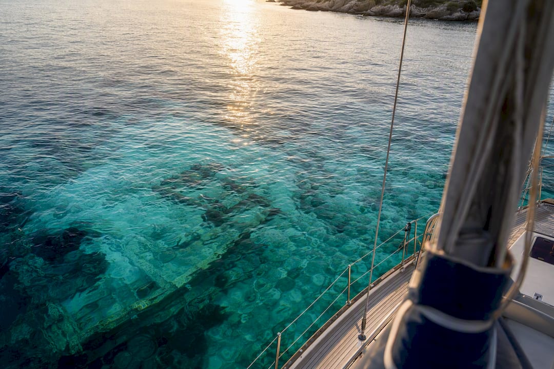
Why this matters for history: submerged wrecks extend the island’s archaeological footprint well beyond the ruins on land, hinting at maritime traffic, storms, or incidents that never made it into any written record. Local diving experts treat the underwater terrain as an extension of the same story the Roman observation post tells on shore.
A few things worth knowing before you go in:
- Visibility varies with season and recent weather, so ask your skipper for a read on current conditions
- Wreck sites reward a “look, don’t touch” approach, both out of respect and because loose fragments can be more delicate than they look
- Beginners should stick to shallow snorkeling routes; deeper wreck approaches call for a guide with local knowledge
- A guide from Neos Marmaras or Paliouri who knows the specific entry points saves you from wasting your trip circling blind
Quick fact: The combination of Roman ruins on land and wreck remnants offshore is part of what makes Kelyfos read less like a single archaeological site and more like a small underwater museum.
How Do You Visit Kelyfos Today?
There’s no public route to Kelyfos. Getting there means booking a private charter out of Neos Marmaras or Paliouri, since the island has no dock, no ferry line, and no formal infrastructure of any kind waiting for you on the other side.
What greets you on arrival is mostly rock. Landing spots are limited, sandy patches are rare, and the paths leading up toward the ruins are steep and uneven. You’ll likely spot goats picking their way across slopes that look almost too steep to climb, along with seabirds working the cliffs above.
Before you commit to a landing, run through this short checklist:
- Wear closed-toe shoes with real grip, not sandals
- Bring more water than you think you’ll need; there is nothing to buy on the island
- Confirm your skipper or guide is comfortable with current sea conditions before attempting to land
- Carry basic first-aid items, since the nearest help is a boat ride away
- Skip the landing entirely if wind or swell makes the approach look risky
Pro Tip: Pair the historical stop with time in the water. A half-day rhythm of offshore viewing, a snorkel near the wreck points, and a short supervised landing (conditions allowing) covers both the archaeology and the marine life without rushing either one. Private charters like those run by Halkidiki Boat Sailing build the day around exactly that pacing.
Visiting Responsibly: Rules for Ruins and Wrecks
Kelyfos survives in its current state because almost nobody disturbs it. Keeping it that way comes down to a short list of habits.
- Photograph the ruins freely, but never touch, move, or climb on the stonework
- Leave every artifact exactly where you find it, whether on land or underwater
- Follow your guide’s instructions on where to walk and where to swim
- Avoid trampling vegetation or approaching seabird nesting areas too closely
The stakes are real. Greece protects underwater cultural heritage under its national frameworks, and disturbing a wreck site is treated as more than a casual misstep. The same logic extends to the unexcavated Roman ruins on land, where careless footing does damage that no amount of good intentions can undo.
If you spot something that looks freshly exposed, whether a stone fragment on the trail or debris near a wreck, report it rather than pocket it. The municipality of Sithonia and the regional archaeological ephorate are the right contacts for anything that looks newly uncovered or disturbed.
A Sample Half-Day Visit to Kelyfos
A typical outing runs in a clear sequence, timed to fit a half-day charter without feeling rushed.
- Departure from Neos Marmaras or Paliouri (allow 20 to 30 minutes of transit to reach the island)
- Offshore pass around the island to appreciate the turtle-shaped outline from the water
- Snorkeling stop near known wreck points, typically 45 minutes to an hour
- Short landing, conditions permitting, to view the ruins from a respectful distance (20 to 30 minutes)
- Return cruise, often timed to catch late afternoon light on the gulf
A half-day version of this plan runs roughly four hours door to door; stretching it into a full-day option leaves room for a second snorkel stop or a slower lunch anchored offshore.
Pack light but pack right:
- Closed-toe shoes for any landing attempt
- Extra water and sun protection (there’s no shade once you’re off the boat)
- A snorkel mask, or arrange a rental through your charter
- A waterproof camera or phone case
- A small first-aid kit
How Kelyfos Changed Hands and Uses Across the Centuries
The clearest chapter in the island’s story belongs to the Roman period, when the observation structures on the northeast side were built to track movement through the Toronean Gulf. Before that, the historical record goes quiet. There’s no confirmed prehistoric settlement, though the surrounding gulf was already a working shipping corridor by antiquity, which makes an unmanned watch point like Kelyfos a logical piece of regional maritime control.
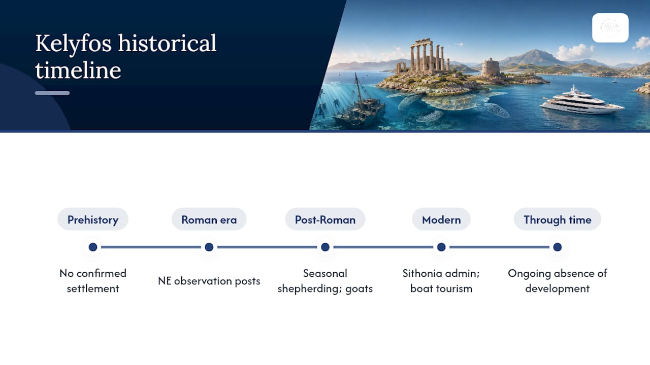
After the Roman period, the trail turns informal rather than documented. Shepherds are believed to have used the island seasonally, likely grazing goats there and leaving without any permanent structures beyond what already existed. Those goats, or their descendants, still roam the island today as a feral population, one of the more visible living links between the ancient site and the present.
The modern chapter is administrative rather than dramatic. Kelyfos falls under the municipality of Sithonia, with no year-round residents and no active development plan. Tourism arrived gradually, driven almost entirely by private boat operators out of Neos Marmaras and Paliouri rather than any formal visitor program.
What ties this timeline together is absence: absence of continuous settlement, absence of major construction after the Roman period, absence of any large-scale excavation. That absence is precisely why the ruins and the goats and the seabirds all still exist in roughly the same rough, undisturbed state they’ve held for centuries.
Who Owns and Administers Kelyfos Today
Kelyfos carries no private residential claim and no year-round population, which puts its administration squarely in public hands. The island falls under the jurisdiction of the municipality of Sithonia, placing it within the same regional authority that oversees nearby coastal towns like Nikiti and Neos Marmaras.
That administrative status matters practically. Because no private owner controls access, visiting rights are effectively open to anyone with a seaworthy boat, provided they respect the island’s fragile ruins and its lack of facilities. There’s no entry fee, no booking office, and no ranger station, a reflection of how lightly Greek regional authorities have needed to manage a site this small and this remote from major population centers.
The absence of formal excavation permits or ongoing archaeological programs also tells its own story. Unlike heavily studied ancient sites elsewhere in Halkidiki, Kelyfos has not attracted a sustained academic dig, likely a mix of its small scale, its remote location, and the logistical cost of running fieldwork on an island with no dock or power supply. Regional tourism bodies reference the ruins in their guidance, but the deeper archaeological cataloging that would come with a full excavation simply has not happened yet.
For visitors, this translates into a simple reality: no permission slip is required to approach Kelyfos by boat, but the informal nature of its oversight makes visitor conduct the main safeguard protecting what’s left of the site.
Myths, Legends, and the Meaning Behind “Turtle Island”
The nickname “Turtle” isn’t a marketing invention. Chelona, the Greek word for turtle, describes what the island’s domed shape genuinely looks like from a passing boat, low, rounded, and slow-seeming against the open water of the gulf. That visual nickname has likely outlasted any formal ancient name the island may once have carried.
Local lore around Kelyfos leans more atmospheric than documented, tied to its isolation and its uninterrupted history of goats, birds, and quiet rather than any single dramatic legend. Fishermen and local sailors have long treated the island as a landmark and a waypoint rather than a destination, a place you sail past or around rather than toward, which shapes how it sits in regional memory: less a site of stories and more a fixed point on the mental map of the gulf.
The cultural weight it carries today comes largely from that contrast. In a stretch of coastline that includes lively towns like Neos Marmaras and Paliouri, Kelyfos stands out precisely because nothing has happened there in centuries. Its cultural heritage value lies less in mythology and more in what it represents: an untouched, unclaimed piece of the ancient gulf’s working history, still readable in stone and shipwreck for anyone willing to make the trip.
Why the Island Still Looks Roman Today
The condition of Kelyfos right now is basically a direct result of what didn’t happen to it. No sustained settlement after antiquity, no major construction boom, no tourism infrastructure push, and, notably, no formal excavation that would have disturbed the ruins in the name of studying them.
That lack of disturbance is a double-edged sword. On one hand, it means the Roman-era structures on the northeast side remain in something close to their original, if weathered, condition rather than being buried under later development. On the other hand, it means there’s genuinely limited scholarly understanding of exactly how the site functioned, how large the original garrison or watch post might have been, or what daily life there looked like two thousand years ago.
Preservation efforts, such as they exist, are mostly passive: the island’s remoteness and lack of facilities naturally limit foot traffic, and Greek protections around underwater cultural heritage discourage disturbance of the nearby wreck sites. There’s no active restoration program, and none is clearly needed yet given how little pressure the ruins face.
The real threat going forward isn’t weather or time; it’s rising visitor traffic without matching guidance. As private charters make Kelyfos more accessible from Neos Marmaras and Paliouri, the informal preservation that isolation once provided will depend increasingly on visitors choosing to look rather than touch.
Why Kelyfos Sticks With You Long After the Boat Ride
Kelyfos matters to local maritime history because it’s one of the few sites in the Toronean Gulf where you can see, in a single afternoon, both a Roman-era watch post and the wrecks that same stretch of water eventually claimed. On the water, that connection between land and sea history becomes obvious in a way no map or article fully captures.
The most useful thing to know before going is that patience beats ambition. Landings that get rushed because someone wants to see the ruins up close, regardless of sea conditions, are the ones that end in a scraped knee or a slip on wet rock. The better call is almost always to read the swell first and let that decide whether today is a landing day or an offshore-and-snorkel day.
Halkidiki Boat Sailing runs private charters aboard the yacht “Off The Hook” out of Neos Marmaras, and the approach that works best treats Kelyfos as one stop within a slower day on the water, not a checklist item to rush through.
Where to Verify These Facts or Plan a Visit
For further reading, Visit Central Macedonia covers the island’s geography and ruins, TheDiver details the underwater sites, and Welcome Chalkidiki offers visitor-level practical notes. Locally, the municipality of Sithonia and harbor services in Neos Marmaras can help with logistics.
To arrange a private charter that includes Kelyfos, Halkidiki Boat Sailing’s group and private charter page covers booking options departing from Neos Marmaras.
Sources
- Kelyfos Island Halkidiki – A Guide to Scuba and Snorkel
- Turtle Island Kelyfos – Uninhabited sight and insider spot
- Kelyfos – zxc.wiki
FAQ
What Is Kelyfos Island Known For?
Kelyfos is known for its Roman-era observation ruins on the northeastern side and for ancient shipwreck remnants and coral formations in the surrounding waters.
How Do You Get to Kelyfos Island?
Kelyfos has no public ferry or dock, so visitors reach it by private boat charter from Neos Marmaras or Paliouri.
Is It Safe to Land on Kelyfos?
Landing is possible in calm conditions but the shoreline is rocky and steep, so sturdy footwear and a guide’s assessment of sea conditions are essential before attempting it.
Who Administers Kelyfos Island?
Kelyfos falls under the jurisdiction of the municipality of Sithonia, with no private ownership or permanent residents.
Can You Dive Near the Kelyfos Wrecks?
Yes, the waters around Kelyfos hold wreck remnants and coral formations suited to both snorkeling and diving, though professional guidance is recommended for deeper wreck sites.